FR
°F
Changer les mesures
Meters
Feet
°C
°F
km/h
mph
kts
am/pm
24-hour
Vos paramètres ont été mis à jour
Changer la langue
Deutsch
Español
Italiano
Nederlands
中文
English
Français
日本語
Português
Aujourd'hui
7 jours
Temps
Pêche
La mer
Marées à
United States
Marées à
Virginia
Marées à
Northampton County
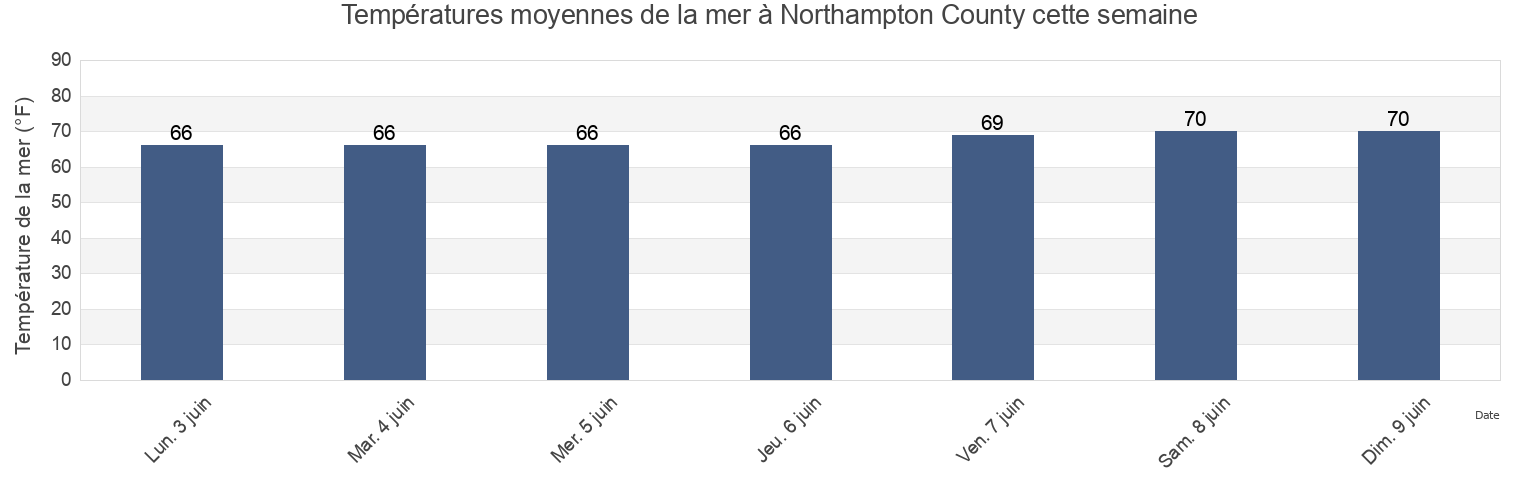
Température de la mer à Northampton County
Température de la mer à Northampton County cette semaine
Plus d'informations sur les marées et le milieu marin pour Northampton County
Marées Aujourd'hui
Marées cette semaine
Temps
Horaire marée pêche
Régions et villes de Northampton County, Virginia, United States
Butler Bluff 2.1 n.mi. WSW of
Fishermans I. 0.4 mile west of
Kiptopeke Beach
Cape Charles
Fishermans I. 1.1 miles northwest of
Old Plantation Flats Lt. 0.5 mi. W of
Cape Charles City 3.3 n.mi. west of
Fishermans I. 1.4 n.mi. WNW of
Old Plantation Light
Cape Charles Coast Guard Station
Fishermans Island
Oyster Harbor
Cape Charles Harbor
Fishermans Island 0.5 n.mi. SW of
Sand Shoal Inlet (coast Guard Station)
Cape Charles off Wise Point
Fishermans Island 1.4 miles WSW of
Ship Shoal Inlet
Afficher plus de lieux
Cherrystone Inlet
Fishermans Island 1.7 n.mi. south of
Smith Beach
Chesapeake Channel (bridge tunnel)
Fishermans Island 2.45nm south of
Smith Island (coast Guard Station)
Chesapeake Channel (Buoy '15')
Fishermans Island 3.2 miles WSW of
Smith Island Shoal southeast of
Chesapeake Channel (Buoy 15)
Great Machipongo Inlet (inside)
Wolf Trap Light 5.8 miles east of
Church Neck Point 1.9 n.mi. W of
Hog Island
Wolf Trap Light 6.1 n.mi. ENE of
Eastville
Hungars Beach
York River Entrance Channel (SE end)
Exmore
Kiptopeke
York Spit Channel N of Buoy 26
Marées près de Northampton County
Oyster Harbor
Eastville
Cherrystone Inlet
Cape Charles
Cape Charles Coast Guard Station
Cape Charles Harbor
Smith Beach
Hungars Beach
Sand Shoal Inlet (coast Guard Station)
Old Plantation Light