FR
°F
Changer les mesures
Meters
Feet
°C
°F
km/h
mph
kts
am/pm
24-hour
Vos paramètres ont été mis à jour
Changer la langue
Deutsch
Español
Italiano
Nederlands
中文
English
Français
日本語
Português
Aujourd'hui
7 jours
Temps
Pêche
La mer
Marées à
United States
Marées à
Virginia
Marées à
Mathews County
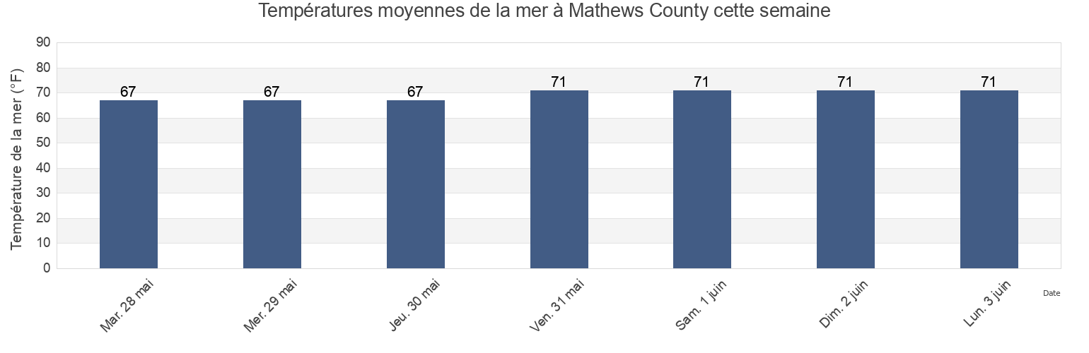
Température de la mer à Mathews County
Température de la mer à Mathews County cette semaine
Plus d'informations sur les marées et le milieu marin pour Mathews County
Marées Aujourd'hui
Marées cette semaine
Temps
Horaire marée pêche
Régions et villes de Mathews County, Virginia, United States
Bethel Beach
Little Creek (Railroad Terminal), Chesapeake Bay
Windmill Point Light
Bland Point Piankatank River
Mathews
Windmill Point Light 2.2 n.mi. ESE of
Cherry Point
Mobjack (East River)
Wolf Trap Light
Gwynn Island
Mobjack East River
Wolf Trap Light 0.5 mile west of
Gwynn Island 1.5 n.mi. east of
New Point Comfort 2.0 n.mi. WSW of
Wolf Trap Light 1.4 n.mi. NNE of
Gwynn Island 8.0 n.mi. east of
New Point Comfort 4.1 n.mi. ESE of
Wolf Trap Light 2.0 n.mi. NW of
Afficher plus de lieux
Horn Harbor Marina
Stingray Point 1.2 n.mi. NE of
Wolf Trap Light 5.2 n.mi. ENE of
Jackson Creek (Deltaville)
Stingray Point 5.5 miles east of
Jackson Creek Deltaville
SW Branch, Severn River, Mobjack Bay
Marées près de Mathews County
Bethel Beach
Mathews
Wolf Trap Light 2.0 n.mi. NW of
Horn Harbor Marina
Wolf Trap Light 0.5 mile west of
Wolf Trap Light
Wolf Trap Light 1.4 n.mi. NNE of
Mobjack East River
Mobjack (East River)
Gwynn Island 1.5 n.mi. east of