FR
°F
Changer les mesures
Meters
Feet
°C
°F
km/h
mph
kts
am/pm
24-hour
Vos paramètres ont été mis à jour
Changer la langue
Deutsch
Español
Italiano
Nederlands
中文
English
Français
日本語
Português
Aujourd'hui
7 jours
Temps
Pêche
La mer
Marées à
United States
Marées à
Virginia
Marées à
City of Hampton
Température de la mer à City of Hampton
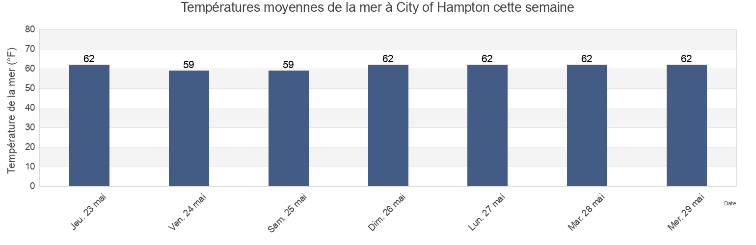
Température de la mer à City of Hampton cette semaine
Plus d'informations sur les marées et le milieu marin pour City of Hampton
Marées Aujourd'hui
Marées cette semaine
Temps
Horaire marée pêche
Régions et villes de City of Hampton, Virginia, United States
0.15nm WSW of Pier No.2
Hampton
Norfolk Harbor Reach (Buoy R 8)
0.2 mile south of
Hampton River
Old Point Comfort
0.55 n.mi. east of
Hampton River entrance
Pig Point
0.8 mile SW of shipbuilding plant
Hampton Roads
Pig Point 1.8 miles northeast of
0.9 mile southwest of
Hampton Roads (sewells Point)
Sewells Point
1.5 miles SW of shipbuilding plant
Hampton Roads entrance midchannel
Sewells Point (Naval Station Norfolk)
Afficher plus de lieux
Buckroe Beach
James River Entrance
Sewells Point pierhead
Cape Henry Light 8.3 mi. NW of
Middle Ground 1 mile south of
Thimble Shoal Channel (west end)
Channel middle
Newport News
Thimble Shoal Channel 2.4 n.mi east of Ft. Monroe
Dandy Haven Marina
Newport News Channel west end
Willoughby Bay entrance
East Hampton
Norfolk Harbor Reach (Buoy R '8')
Willoughby Spit 0.8 mile northwest of
Marées près de City of Hampton
East Hampton
Buckroe Beach
Hampton River entrance
Hampton
Dandy Haven Marina
Messick Point Back River
Hampton River
Messick Point (Back River)
Poquoson
Old Point Comfort