FR
°F
Changer les mesures
Meters
Feet
°C
°F
km/h
mph
kts
am/pm
24-hour
Vos paramètres ont été mis à jour
Changer la langue
Deutsch
Español
Italiano
Nederlands
中文
English
Français
日本語
Português
Aujourd'hui
7 jours
Temps
Pêche
La mer
Marées à
United States
Marées à
New York
Marées à
New York County
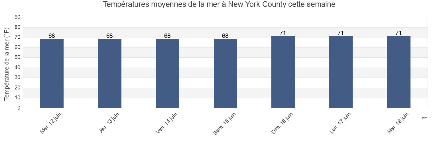
Température de la mer à New York County
Température de la mer à New York County cette semaine
Plus d'informations sur les marées et le milieu marin pour New York County
Marées Aujourd'hui
Marées cette semaine
Temps
Horaire marée pêche
Régions et villes de New York County, New York, United States
120th Street
Gueque
Mill Rock northeast of
130th Street
Hallets Cove
Mill Rock west of
37th Avenue, Long Island City, East River
Harlem River (Randalls Island)
New York City (East 41st Street)
48th Street
Harlem River Randalls Island
Off Winthrop Ave. Astoria
56th St
Hell Gate (East River)
Pier 67 off 19th Street
7th Avenue
Hell Gate Wards Island
Port Morris
Afficher plus de lieux
81st Street
Hell Gate(off Mill Rock)
Port Morris (Stony Point)
Bananas Point
Horns Hook
Queensboro Bridge
Cromakill Creek N J Turnpike
Hunters Point (Newtown Creek)
Roosevelt Island, north end, East River
East 107th Street
Hunters Point Newtown Creek
South Brother Island NW of
East 110th Street
Lawrence Point
Turtles
East 19th Street
Liberty Island
Union Stock Yards
East 27th Street, Bellevue Hospital, East River
Macombs Dam Bridge
Wards Island
East 41st Street New York City
Madison Ave. Bridge
west of off 63rd Street
east of
Madison Avenue Bridge, Harlem River
west of off 67th Street
east of off 36th Avenue
Manhattan
west of off 75th Street
Edgewater
Manhattan 26th street
Willis Ave. Bridge 0.1 mile NW of
Grants Tomb
Manhattan off 31st Street
Wolcott Avenue
Marées près de New York County
Turtles
7th Avenue
Manhattan
56th St
east of off 36th Avenue
west of off 67th Street
west of off 75th Street
west of off 63rd Street
Queensboro Bridge
east of