FR
°F
Changer les mesures
Meters
Feet
°C
°F
km/h
mph
kts
am/pm
24-hour
Vos paramètres ont été mis à jour
Changer la langue
Deutsch
Español
Italiano
Nederlands
中文
English
Français
日本語
Português
Aujourd'hui
7 jours
Temps
Pêche
La mer
Marées à
United States
Marées à
Massachusetts
Marées à
Dukes County
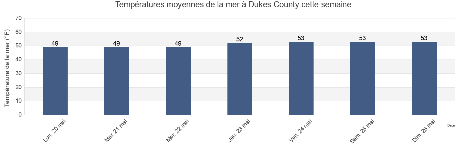
Température de la mer à Dukes County
Température de la mer à Dukes County cette semaine
Plus d'informations sur les marées et le milieu marin pour Dukes County
Marées Aujourd'hui
Marées cette semaine
Temps
Horaire marée pêche
Régions et villes de Dukes County, Massachusetts, United States
Abels Hill
Hedge Fence-LHommedieu Shoal between
Penikese Island 0.8 mile northwest of
Bend-in-the-Road Beach
Juniper Point
Quick's Hole
Bristol Beach
Katama Bay
Quicks Hole
Canapitsit Channel
Kettle Cove
Quicks Hole (middle)
Cape Poge Light 1.4 miles west of
L'Hommedieu Shoal
Quicks Hole North side
Cape Poge Lt. 1.7 miles SSE of
Lamberts Cove
Raymond Street
Afficher plus de lieux
Cape Poge Lt. 3.2 miles northeast of
LHommedieu Shoal north of west end
Robinsons Hole 1.2 miles southeast of
Cedar Tree Neck
Lighthouse Beach
Robinsons Hole Nashuon Point
Chappaquoit Beach
Little Harbor
Round Hill Point
Chappaquoit Point
Lobsterville Beach
South Beach State Park
Chappaquoit Point West Falmouth Harbor
Long Point
South Cape Beach
Clarks Point
Lucy Vincent Beach
Squibnocket Beach
Cleveland Ledge
Martha's Vineyard GPS Buoy
Squibnocket Point
Cuttyhunk
Marthas Vineyard GPS Buoy
Surf Drive Beach
Cuttyhunk Pond entrance
Menauhant Beach
Tarpaulin Cove 1.5 miles east of
Dumpling Rocks 0.2 mile southeast of
Menemsha Beach
Uncatena Island (South Side)
East Beach
Menemsha Bight
Vineyard Haven
East Chop 1 mile north of
Menemsha Harbor Ma
Vineyard Haven Harbor
East Chop-Squash Meadow
Muskeget Channel
Waquoit Bay entrance
East Chop-Squash Meadow between
Muskeget Rock 1.3 miles southwest of
Wasque Point (Chappaquiddick Island)
Edgartown
No Man's Land
Wasque Point Chappaquiddick Island
Edgartown Great Pond
Nobska Point 1 mile southeast of
Weepecket Island south of
Falmouth Heights
Nobska Point 1.8 miles east of
West Chop 0.2 mile west of
Falmouth Heights Beach
Nomans Land
West Chop 0.8 mile north of
Felix Neck
Norton Point 0.5 mile north of
West Falmouth Harbor
Fuller Street
Norton Point Beach
West Island (west side)
Gay Head
Oak Bluffs
West Island 1 mile Southeast of
Gay Head 1.5 miles northwest of
Oceanographic Institution
West Tisbury
Gay Head 3 miles north of
Off Chilmark Pond
Woodneck Beach
Gay Head 3 miles northeast of
Off Jobs Neck Pond
Woods Hole
Great Rock Bight
Off Lake Tashmoo
Woods Hole Oceanographic Institute
Gull I. and Nashawena I. between
Old Silver Beach
Woods Hole The Strait
Hedge Fence Lighted Gong Buoy 22
Penikese Island
Hedge Fence-L'Hommedieu Shoal
Penikese Island 0.2 mile south of
Marées près de Dukes County
West Tisbury
Great Rock Bight
Cedar Tree Neck
Abels Hill
Lucy Vincent Beach
Lamberts Cove
Long Point
Off Chilmark Pond
Menemsha Harbor Ma
Menemsha Beach