FR
°F
Changer les mesures
Meters
Feet
°C
°F
km/h
mph
kts
am/pm
24-hour
Vos paramètres ont été mis à jour
Changer la langue
Deutsch
Español
Italiano
Nederlands
中文
English
Français
日本語
Português
Aujourd'hui
7 jours
Temps
Pêche
La mer
Marées à
United States
Marées à
Georgia
Marées à
Chatham County
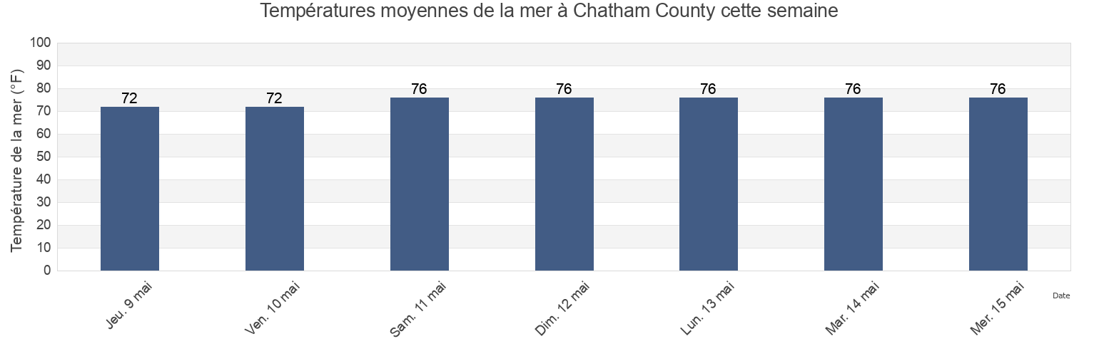
Température de la mer à Chatham County
Température de la mer à Chatham County cette semaine
Plus d'informations sur les marées et le milieu marin pour Chatham County
Marées Aujourd'hui
Marées cette semaine
Temps
Horaire marée pêche
Régions et villes de Chatham County, Georgia, United States
2nd Street (Tybee Island)
Fort Mcallister (Ogeechee River)
Raccoon Key
610 Statute Mile Mark
Fort McAllister Ogeechee River
Range A Light Bear River
Beach Hammock
Fort Pulaski
Romerly Marsh Creek
Bear River Entrance
Fort Pulaski 1.8 miles above
S C L Rr Bridge
Bloody Point (Daufuskie Island)
Fort Pulaski 4.8 miles above
S.C.L. Rr. Bridge
Bloody Point Daufuskie Island
Good Hope Landing (South Of)
Savannah
Afficher plus de lieux
Bloody Pt. 0.5 mile north of New River
Good Hope Landing South Of
Savannah Bull Street
Bloody Pt. 0.5 mile west of New River
Greys Island
Savannah River Entrance (between jetties)
Bradley Point (Bradley River)
Hargray Pier (Daufuskie Island)
Savannah River Entrance Fort Pulaski
Bradley Point Bradley River
Hargray Pier Daufuskie Island
Savannah Sheraton Resort Hotel
Bradley Point NNE of
Highway Bridge (Ogeechee River)
Savannah southeast of highway bridge
Bull River 2 miles below hwy. bridge
Highway Bridge Ogeechee River
Seaboard Coast Line Railroad
Burnside Island SE of Burnside River
Isle of Hope
Skidaway Island
Burntpot Island west of Skidaway River
Isle of Hope (Skidaway River)
Skidaway Island N End Wilmington River
Butter Bean Beach
Isle of Hope City SE of Skidaway River
Skidaway Narrows
Cane Patch Creek Entrance
Isle of Hope City Skidaway River
Skidaway River north entrance
Coffee Bluff (Forest River)
Isle Of Hope Skidaway River
South Channel western end
Coffee Bluff Forest River
Joe's Cut
South of Kilkenny Creek Entrance
Cook Landing Cemetery
Joes Cut Wilmington River
South Ossabaw Island Bear River
Daufuskie Landing (Daufuskie Island)
Kilkenny Club (Kilkenny Creek)
St. Catherines Sound Entrance
Daufuskie Landing Daufuskie Island
Kilkenny Club Kilkenny Creek
Thunderbolt
Daufuskie Landing Light south of
King Island west of
Thunderbolt SE of Wilmington River
Delegal Creek Marina
Kings Island Channel Savannah River
Turnbridge Landing (Salt Water Creek)
Doughboy Island
Lazaretto Creek Entrance N of Bull River
Turnbridge Landing Salt Water Creek
Dutch Island SE of Skidaway River
Little Back River Hwy. 17 Back River S.C.
Tybee Creek Entrance
Egg Islands
Little Don Island east of Vernon River
Tybee Island
Elba Island Cut NE of Savannah River
Little Ogeechee River Entrance
Tybee Light
Elba Island NE of Savannah River
Little Ogeechee River Entrance north of
Tybee South End Sand Bar
Elba Island west of Savannah River
Little Wassaw Island SW of
Vernon R. 1.2 miles S of Possum Point
Entrance off Beach Hammock
Long Island NNE of Skidaway River
Vernon View
Entrance off Wassaw Island
Long Island south of Skidaway River
Vernon View (Burnside River)
Fields Cut (Wright River)
McQueen Island Cut
Walls Cut Turtle Island
Fields Cut Wright River
Montgomery
Wassaw Island N of E end Wassaw Sound
Fig Island north of Back River
Montgomery Vernon River
Wassaw Island SSW of
Florida Passage (Bear River)
North Entrance
Whitemarsh Island
Florida Passage (Ogeechee River)
North of Big Tom Creek Entrance
Wilmington Island
Florida Passage (south)
Northwest of Newell Creek Entrance
Wilmington Island SSE of Bull River
Florida Passage Bear River
Oatland Island north tip
Wilmington R. 0.5 mi. S of Turners Creek
Florida Passage N of Ogeechee River
Odingsell River Entrance
Wilmington R. ent. south channel
Florida Passage Ogeechee River
Pelican Point
Wilmington River ent. off Cabbage Island
Fort Jackson
Pigeon Island SSE of Skidaway River
Wright R. 0.2 mile above Walls Cut
Fort Mc Allister Ogeechee River
Port Wentworth 0.2 mile above
Marées près de Chatham County
Isle of Hope
Skidaway Narrows
Long Island NNE of Skidaway River
Isle of Hope City Skidaway River
Burntpot Island west of Skidaway River
Butter Bean Beach
Isle Of Hope Skidaway River
Isle of Hope (Skidaway River)
Long Island south of Skidaway River
Isle of Hope City SE of Skidaway River