Horaires des marées à Beaufort County aujourd'hui

Horaires des marées pour Beaufort County, South Carolina, United States

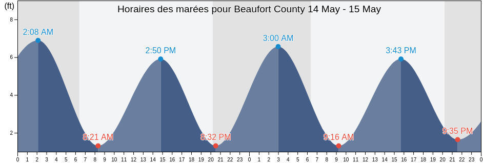
Jeudi 25 avril 2024, 07:22 EDT (GMT -0400). La marée est en train de monter à Beaufort County. Comme vous pouvez le voir dans la courbe des marées, la marée la plus haute de 7.55ft est à 22:34 et la marée la plus basse de 0.33ft était à 04:24. Cliquez ici pour voir les horaires de marée de Beaufort County pour la semaine.

Prochaine marée haute

La prochaine marée haute est à
10:17

Prochaine marée basse

La prochaine marée basse est à
16:18

Horaires des marées pour Beaufort County

Horaires des marées pour Beaufort County cette semaine
Jour Horaires des marées pour Beaufort County Lever et coucher du soleil
1ère marée 2ème marée 3e marée 4ème marée
jeu. 2504:24
0.33 ft
10:17
6.56 ft
16:18
0.33 ft
22:34
7.55 ft
06:41 20:00
ven. 2605:02
0.33 ft
10:53
6.56 ft
16:55
0.33 ft
23:10
7.55 ft
06:40 20:01
sam. 2705:42
0.33 ft
11:33
6.23 ft
17:35
0.33 ft
23:53
7.55 ft
06:39 20:01
dim. 2806:26
0.66 ft
12:21
6.23 ft
18:19
0.66 ft
06:38 20:02
lun. 2900:45
7.22 ft
07:14
0.66 ft
13:17
6.23 ft
19:11
0.66 ft
06:37 20:03
mar. 3001:45
7.22 ft
08:10
0.98 ft
14:19
6.23 ft
20:12
0.98 ft
06:36 20:03
mer. 102:49
7.22 ft
09:13
0.66 ft
15:22
6.56 ft
21:24
0.98 ft
06:35 20:04

Meilleur periode pêche à Beaufort County hoje Journée favorable pour la pêche

Meilleures heures pour la pêche

De 08:28 à 10:28

Opposé au transit lunaire (Lune basse)

De 20:59 à 22:59

Transit lunaire (Lune haute)

Mauvaises heures pour la pêche

De 06:56 à 07:56

Coucher de la lune

De 21:29 à 22:29

Lever de la lune

Cliquez ici pour voir les heures de pêche de Beaufort County pour la semaine.

Météo actuelle à Beaufort County

Passages nuageux

Temps

Couverture nuageuse 26%
Température

Température

68°F
Min 65°F/Max 72°F
Vent

Vent

9 mph
Rafale de vent 14 mph
Humidité

Humidité

72%
Point de rosée 56°F

Cliquez ici pour voir la météo de Beaufort County pour la semaine

Météo du jour à Beaufort County

Le soleil s'est levé à 06:41 et le coucher du soleil sera à 20:00. Il y aura 13 heures et 19 minutes de soleil et la temperature moyenne est 69°F. La temperature actuelle de l'eau est 64°F. et la temperature moyenne de l'eau est 64°F.

Météo Beaufort County aujourd ́hui
0 h 3 h 6 h 9 h 12 h 15 h 18 h 21 h 24 h
Passages nuageuxPassages nuageuxPassages nuageuxPassages nuageuxPassages nuageuxPassages nuageuxPassages nuageuxPassages nuageuxPluie irrégulière à proximité
67°F69°F68°F69°F71°F71°F68°F67°F67°F

Cliquez ici pour voir la météo de Beaufort County pour la semaine

Plus d'informations sur les marées et le milieu marin pour Beaufort County

Régions et villes de Beaufort County, South Carolina, United States

Albergottie CreekCoosaw Island South of Morgan RiverNew River (Rt. 170 Bridge)
Albergottie Creek Rt. 21 BridgeCorning Landing Whale BranchOtter Island
Ashe Island Cut St. Helena SoundCowen Creek (Route 21 Bridge)Parris Island (Marine Corps Recruit Depot)
Ashe Island Cut SW of Coosaw RiverCowen Creek Rt. 21 BridgeParris Island Beaufort River
Ashepoo Coosaw CutoffDaufuskie IslandParris Island Lookout Tower Broad River
Ashepoo Coosaw Cutoff ICWWDaws Island SE of Broad RiverParris Island Marine Corps Recruit Depot
Ashepoo River off Jefford Creek entranceDaws Island south of Chechessee RiverParrot Creek Coosaw Island
Bailey's LandingDistant Island (Cowen Creek)Pelican Bank St. Helena Sound
Baileys Landing (Okatee River Colleton River)Distant Island Cowen CreekPeters Point (St. Pierre Creek)
Battery Creek (4 Mi. Above Entrance)Distant Island Creek (Upper End Cowen Creek)Pinckney Island (Mackay Creek Chechessee River)
Battery Creek 4 Mi. Above EntranceDistant Island Creek Upper End Cowen CreekPinckney Island Mackay Creek Chechessee River
Bay Point Island S of Broad River entranceDolphin HeadPine Island (Ramshorn Creek Cooper River)
BeaufortEdding Point (Edding Creek)Pine Island Ramshorn Creek Cooper River
Beaufort Airport Beaufort RiverEdding Point Edding CreekPine Island South Edisto River
Beaufort Beaufort RiverEdisto Beach (Edisto Island)Port Royal
Beaufort RiverEdisto Beach Edisto IslandPort Royal Plantation (Hilton Head Island)
Beaufort River EntranceEdisto Marina (Big Bay Creek Entrance)Port Royal Plantation Hilton Head Island
BlufftonEdisto Marina Big Bay Creek EntrancePort Royal Plantation Tower east of
Braddock Point (Hilton Head Island)Egg Bank St. Helena SoundPort Royal Sound
Braddock Point Hilton Head IslandEuhaw Creek (2.5 Mi. Above Entrance)Ramshorn Creek Light E of Cooper River
Braddock Point SW of Calibogue SoundEuhaw Creek 2.5 Mi. Above EntranceRose Dew Creek
Brickyard Point (Brickyard Creek)Fenwick Island Cut South Edisto RiverRt 170 bridge
Brickyard Point Brickyard CreekFort FremontSams Point (Lucy Point Creek)
Broad Creek (Hilton Head Island)Fripp InletSams Point Lucy Point Creek
Broad River Bridge S of Broad RiverFripp Inlet BridgeSams Point Northwest of Coosaw River
Broad River Entrance Point Royal SoundFripp Inlet Fripp IslandSavage Creek (Bull Creek)
Bull Creek (Bull Island South Cooper River)Fripp IslandSavage I. Savage Creek Bull Creek
Bull Creek Bull Island South Cooper RiverHaig Point (Daufuskie Island Cooper River)Scott Creek 0 5 mi above ent Big Bay Creek
Bull Island NorthHaig Point Daufuskie Island Cooper RiverShell Point
BurtonHaig Point Light NW of Cooper RiverShell Point (Hwy. 170 Bridge)
Byrd Creek Entrance SE of Broad RiverHarbor River BridgeSkull Creek (North Entrance Hilton Head Island)
Calibogue Cay (Broad Creek Hilton Head Island)Hilton HeadSkull Creek (South Entrance Hilton Head Island)
Calibogue Cay Broad Creek Hilton Head IslandHilton Head IslandSkull Creek north entrance
Calibogue SoundHunting IslandSkull Creek North Entrance Hilton Head Island
Callawassie Creek (Colleton River)Hutchinson IslandSkull Creek south entrance
Callawassie Island (South Colleton River)Hutchinson Island Ashepoo RiverSkull Creek South Entrance Hilton Head Island
Callawassie Island Bridge (Colleton River)Hwy 170 bridgeSouth Edisto River entrance
Callawassie Island Bridge Colleton RiverJenkins Creek (1 Mi. Above Entrance)Southeast Channel entrance
Callawassie Island South Colleton RiverJenkins Creek (Polawana Island)Spanish Wells Calibogue Sound
Capers Creek (Cowen Creek St. Helena Island)Jenkins Creek 1 Mi. Above EntranceStation Creek (County Landing)
Capers Creek Cowen Creek St Helena IslandJenkins Creek Polawana IslandStation Creek (West End)
Capers Island (Trenchards Inlet)Johnson Creek Bridge (Hunting Island)Station Creek County Landing
Capers Island Trenchards InletLaurel BayStation Creek West End
Carters Dock (Big Bay Creek)Lemon IslandSummerhouse Point (Bull River)
Carters Dock Big Bay CreekLemon Island South Chechessee RiverSummerhouse Point Bull River
Chechessee Bluff (Chechessee River)Little Barnwell I. E of Whale Branch RiverThe Folly Hilton Head Island
Chechessee Bluff Chechessee RiverLucy Point Creek EntranceTriton Head
Chowan CreekMacKay Creek south entranceVictoria Bluff
Clarendon PlantationMarine Corps Air Station (Brickyard Creek)Village Creek Cemetery
Club Bridge Creek Ent. (Trenchards Inlet)Marine Corps Air Station Brickyard CreekVillage Creek Entrance
Coffin PointMoreland CemeteryWhale Branch Entrance
Colleton River EntranceMorgan Island NE of Coosaw RiverWhale Branch River
Combahee RiverMorgan Island North end Coosaw River