Horaires des marées à Chatham County aujourd'hui

Horaires des marées pour Chatham County, Georgia, United States

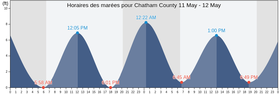
Mardi 16 avril 2024, 04:03 EDT (GMT -0400). La marée est en train de descendre à Chatham County. Comme vous pouvez le voir dans la courbe des marées, la marée la plus haute de 6.89ft était à 03:39 et la marée la plus basse de 1.31ft est à 22:21. Cliquez ici pour voir les horaires de marée de Chatham County pour la semaine.

Prochaine marée haute

La prochaine marée haute est à
16:19

Prochaine marée basse

La prochaine marée basse est à
10:09

Horaires des marées pour Chatham County

Horaires des marées pour Chatham County cette semaine
Jour Horaires des marées pour Chatham County Lever et coucher du soleil
1ère marée 2ème marée 3e marée 4ème marée
mar. 1603:39
6.89 ft
10:09
1.64 ft
16:19
6.23 ft
22:21
1.31 ft
06:54 19:55
mer. 1704:36
6.89 ft
11:10
1.31 ft
17:16
6.23 ft
23:24
1.31 ft
06:53 19:55
jeu. 1805:31
6.89 ft
12:00
1.31 ft
18:11
6.56 ft
06:51 19:56
ven. 1900:18
0.98 ft
06:23
6.89 ft
12:43
0.98 ft
19:00
7.22 ft
06:50 19:57
sam. 2001:06
0.66 ft
07:11
7.22 ft
13:22
0.66 ft
19:44
7.55 ft
06:49 19:57
dim. 2101:50
0.66 ft
07:54
7.22 ft
13:59
0.66 ft
20:23
7.87 ft
06:48 19:58
lun. 2202:32
0.33 ft
08:34
7.22 ft
14:35
0.33 ft
20:59
8.2 ft
06:47 19:59

Meilleur periode pêche à Chatham County hoje Journée moyennement favorable pour la pêche

Meilleures heures pour la pêche

De 12:28 à 14:28

Transit lunaire (Lune haute)

Mauvaises heures pour la pêche

De 02:44 à 03:44

Coucher de la lune

De 12:58 à 13:58

Lever de la lune

Cliquez ici pour voir les heures de pêche de Chatham County pour la semaine.

Météo actuelle à Chatham County

Dégagé

Temps

Couverture nuageuse 0%
Température

Température

70°F
Min 65°F/Max 71°F
Vent

Vent

8 mph
Rafale de vent 16 mph
Humidité

Humidité

78%
Point de rosée 58°F

Cliquez ici pour voir la météo de Chatham County pour la semaine

Météo du jour à Chatham County

Le soleil se levera à 06:54 et le coucher du soleil sera à 19:55. Il y aura 13 heures et 01 minutes de soleil et la temperature moyenne est 69°F. La temperature actuelle de l'eau est 63°F. et la temperature moyenne de l'eau est 63°F.

Météo Chatham County aujourd ́hui
0 h 3 h 6 h 9 h 12 h 15 h 18 h 21 h 24 h
Passages nuageuxDégagéPassages nuageuxPassages nuageuxPassages nuageuxPassages nuageuxPassages nuageuxPassages nuageuxPassages nuageux
67°F70°F68°F70°F71°F70°F68°F68°F68°F

Cliquez ici pour voir la météo de Chatham County pour la semaine

Plus d'informations sur les marées et le milieu marin pour Chatham County

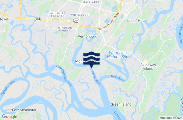
Régions et villes de Chatham County, Georgia, United States

2nd Street (Tybee Island)Fort Mcallister (Ogeechee River)Raccoon Key
610 Statute Mile MarkFort McAllister Ogeechee RiverRange A Light Bear River
Beach HammockFort PulaskiRomerly Marsh Creek
Bear River EntranceFort Pulaski 1.8 miles aboveS C L Rr Bridge
Bloody Point (Daufuskie Island)Fort Pulaski 4.8 miles aboveS.C.L. Rr. Bridge
Bloody Point Daufuskie IslandGood Hope Landing (South Of)Savannah
Bloody Pt. 0.5 mile north of New RiverGood Hope Landing South OfSavannah Bull Street
Bloody Pt. 0.5 mile west of New RiverGreys IslandSavannah River Entrance (between jetties)
Bradley Point (Bradley River)Hargray Pier (Daufuskie Island)Savannah River Entrance Fort Pulaski
Bradley Point Bradley RiverHargray Pier Daufuskie IslandSavannah Sheraton Resort Hotel
Bradley Point NNE ofHighway Bridge (Ogeechee River)Savannah southeast of highway bridge
Bull River 2 miles below hwy. bridgeHighway Bridge Ogeechee RiverSeaboard Coast Line Railroad
Burnside Island SE of Burnside RiverIsle of HopeSkidaway Island
Burntpot Island west of Skidaway RiverIsle of Hope (Skidaway River)Skidaway Island N End Wilmington River
Butter Bean BeachIsle of Hope City SE of Skidaway RiverSkidaway Narrows
Cane Patch Creek EntranceIsle of Hope City Skidaway RiverSkidaway River north entrance
Coffee Bluff (Forest River)Isle Of Hope Skidaway RiverSouth Channel western end
Coffee Bluff Forest RiverJoe's CutSouth of Kilkenny Creek Entrance
Cook Landing CemeteryJoes Cut Wilmington RiverSouth Ossabaw Island Bear River
Daufuskie Landing (Daufuskie Island)Kilkenny Club (Kilkenny Creek)St. Catherines Sound Entrance
Daufuskie Landing Daufuskie IslandKilkenny Club Kilkenny CreekThunderbolt
Daufuskie Landing Light south ofKing Island west ofThunderbolt SE of Wilmington River
Delegal Creek MarinaKings Island Channel Savannah RiverTurnbridge Landing (Salt Water Creek)
Doughboy IslandLazaretto Creek Entrance N of Bull RiverTurnbridge Landing Salt Water Creek
Dutch Island SE of Skidaway RiverLittle Back River Hwy. 17 Back River S.C.Tybee Creek Entrance
Egg IslandsLittle Don Island east of Vernon RiverTybee Island
Elba Island Cut NE of Savannah RiverLittle Ogeechee River EntranceTybee Light
Elba Island NE of Savannah RiverLittle Ogeechee River Entrance north ofTybee South End Sand Bar
Elba Island west of Savannah RiverLittle Wassaw Island SW ofVernon R. 1.2 miles S of Possum Point
Entrance off Beach HammockLong Island NNE of Skidaway RiverVernon View
Entrance off Wassaw IslandLong Island south of Skidaway RiverVernon View (Burnside River)
Fields Cut (Wright River)McQueen Island CutWalls Cut Turtle Island
Fields Cut Wright RiverMontgomeryWassaw Island N of E end Wassaw Sound
Fig Island north of Back RiverMontgomery Vernon RiverWassaw Island SSW of
Florida Passage (Bear River)North EntranceWhitemarsh Island
Florida Passage (Ogeechee River)North of Big Tom Creek EntranceWilmington Island
Florida Passage (south)Northwest of Newell Creek EntranceWilmington Island SSE of Bull River
Florida Passage Bear RiverOatland Island north tipWilmington R. 0.5 mi. S of Turners Creek
Florida Passage N of Ogeechee RiverOdingsell River EntranceWilmington R. ent. south channel
Florida Passage Ogeechee RiverPelican PointWilmington River ent. off Cabbage Island
Fort JacksonPigeon Island SSE of Skidaway RiverWright R. 0.2 mile above Walls Cut
Fort Mc Allister Ogeechee RiverPort Wentworth 0.2 mile above