Horaires des marées à City and County of San Francisco aujourd'hui

Horaires des marées pour City and County of San Francisco, California, United States

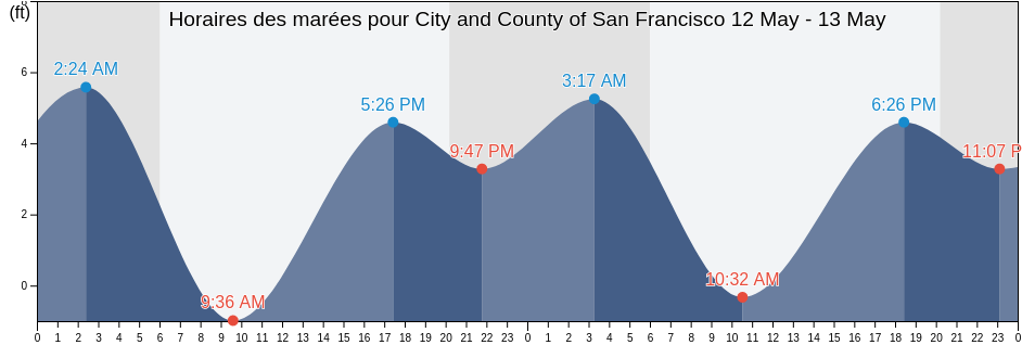
Jeudi 18 avril 2024, 20:39 PDT (GMT -0700). La marée est en train de descendre à City and County of San Francisco. Comme vous pouvez le voir dans la courbe des marées, la marée la plus haute de 4.92ft est à 22:09 et la marée la plus basse de 0.33ft était à 15:06. Cliquez ici pour voir les horaires de marée de City and County of San Francisco pour la semaine.

Prochaine marée haute

La prochaine marée haute est à
22:09

Prochaine marée basse

La prochaine marée basse est à
03:44

Horaires des marées pour City and County of San Francisco

Horaires des marées pour City and County of San Francisco cette semaine
Jour Horaires des marées pour City and County of San Francisco Lever et coucher du soleil
1ère marée 2ème marée 3e marée 4ème marée
jeu. 1802:58
2.3 ft
08:33
4.59 ft
15:06
0.33 ft
22:09
4.92 ft
06:29 19:49
ven. 1903:44
1.64 ft
09:33
4.59 ft
15:44
0.66 ft
22:35
5.25 ft
06:28 19:50
sam. 2004:23
1.31 ft
10:25
4.59 ft
16:17
0.98 ft
22:57
5.25 ft
06:27 19:51
dim. 2104:58
0.98 ft
11:12
4.59 ft
16:47
1.31 ft
23:18
5.25 ft
06:25 19:52
lun. 2205:31
0.33 ft
11:58
4.59 ft
17:16
1.64 ft
23:39
5.58 ft
06:24 19:53
mar. 2306:03
0 ft
12:42
4.27 ft
17:45
1.97 ft
06:23 19:54
mer. 2400:03
5.58 ft
06:35
-0.33 ft
13:28
4.27 ft
18:14
2.3 ft
06:21 19:55

Meilleur periode pêche à City and County of San Francisco hoje Journée moyennement favorable pour la pêche

Meilleures heures pour la pêche

De 14:07 à 16:07

Transit lunaire (Lune haute)

Mauvaises heures pour la pêche

De 03:49 à 04:49

Coucher de la lune

De 14:37 à 15:37

Lever de la lune

Cliquez ici pour voir les heures de pêche de City and County of San Francisco pour la semaine.

Météo actuelle à City and County of San Francisco

Passages nuageux

Temps

Couverture nuageuse 50%
Température

Température

55°F
Min 52°F/Max 60°F
Vent

Vent

8 mph
Rafale de vent 14 mph
Humidité

Humidité

81%
Point de rosée 50°F

Cliquez ici pour voir la météo de City and County of San Francisco pour la semaine

Météo du jour à City and County of San Francisco

Le soleil s'est levé à 06:29 et le coucher du soleil a été à 19:49. Aujourd'hui il y a eu 13 heures et 20 minutes de soleil et la temperature moyenne est 56°F. La temperature actuelle de l'eau est 51°F. et la temperature moyenne de l'eau est 51°F.

Météo City and County of San Francisco aujourd ́hui
0 h 3 h 6 h 9 h 12 h 15 h 18 h 21 h 24 h
Passages nuageuxPassages nuageuxPassages nuageuxPassages nuageuxPassages nuageuxPassages nuageuxPassages nuageuxPassages nuageuxPassages nuageux
53°F58°F55°F58°F60°F58°F55°F54°F53°F

Cliquez ici pour voir la météo de City and County of San Francisco pour la semaine

Plus d'informations sur les marées et le milieu marin pour City and County of San Francisco

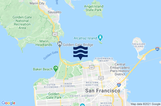
Régions et villes de City and County of San Francisco, California, United States

2nd StreetNorth Point Pier 35 north ofPoint San Pablo midchannel
Alameda Estuary southeast endNorthridge ParkPoint San Pedro
Alameda Naval Air StationOakland (Matson Wharf)Point San Pedro 0.55 nmi. SE of
Alameda Radar Tower 0.9 nmi. SSW ofOakland 7th St. Marine 0.6 nmi. SSW ofPoint San Quentin
Alcatraz (North Point)Oakland AirportPoint San Quentin 0.82 nmi. east of
Alcatraz IslandOakland Airport southwest ofPoint San Quentin 1.3 nmi. east of
Alcatraz Island .8 mi EOakland Airport SWPoint San Quentin 1.9 mi E
Alcatraz Island 0.2 mile west ofOakland Berth 67Point San Quentin 1.9 miles east of
Alcatraz Island 0.5 mile north ofOakland Harbor (Grove Street)Point Simpson Angel I. 1.05 nmi. E of
Alcatraz Island south ofOakland Harbor (Park Street Bridge)Potrero Point
Alcatraz Island southwest ofOakland Harbor Grove StreetPotrero Point 1.08 nmi. east of
Alcatraz Island WOakland Harbor High Street BridgePotrero Point 1.1 mi E
Angel Island .8 mi EOakland Harbor Park Street BridgePotrero Point 2 miles east of
Angel Island (East Garrison)Oakland Harbor Webster StreetPt. Blunt Angel I. 0.25 nmi. east of
Angel Island (west Side)Oakland Harbor WebStreeter StreetPt. Blunt Angel I. 0.8 mi. SE of
Angel Island 0.75 mile east ofOakland Inner HarborRaccoon Strait
Angel Island East GarrisonOakland Inner Harbor ChannelRaccoon Strait off Hospital Cove
Angel Island off Quarry PointOakland Inner Harbor ReachRaccoon Strait off Point Stuart
Aquatic ParkOakland Matson WharfRed Rock .1 E
Baker BeachOakland Middle HarborRed Rock 0.60 nmi. NNE of
Baker Beach (South Bay) 0.3 nmi. NW ofOakland Outer Harbor Entrance LB 3Red Rock east of
Baker s BeachOakland PierRichardson Bay Entrance
Bay Bridge Pier DOakland Yerba Buena IslandRichmond Inner Harbor
Bay Bridge Span B-COcean BeachRincon Point
Berkeley Yacht HarborOcean Beach (Outer Coast)Rincon Point midbay
Berkeley Yacht Harbor .9 mi SOcean Beach Outer CoastRoberts Landing (1.3 Miles West Of)
BlackiesOyster Point 2.8 miles east ofRoberts Landing 1.3 Miles West Of
Bluff Point .1 mi EOyster Point MarinaRockaway Beach
Bluff Point 0.1 mile east ofPacifica State BeachSachuest Beach (2nd Beach)
Bluff Point 1.15 nmi. east ofPalisades ParkSan Francisco
Brooklyn BasinPier 23San Francisco (Golden Gate)
Candlestick PointPinole PointSan Francisco (North Point Pier 41)
Carquinez Bridge I-80Pinole Point 1.18 nmi. west ofSan Francisco Bar
Chevron Oil Company Pier RichmondPinole Point 1.2 mi WSan Francisco Bar north of ship channel
China BeachPinole Point 1.27 nmi. NNW ofSan Francisco Bay Entrance (Golden Gate)
Corte Madera CreekPinole Point 1.42 nmi. NNW ofSan Francisco Bay Entrance (Outside)
Coyote Point 2.3 nmi. NNE ofPinole Point 3.0 nmi. WNW ofSan Francisco North Point Pier 41
Crown Memorial State BeachPinole Point San Pablo BaySan Francisco southern traffic lane N end
Davis Point (midchannel)Pinole ShoalSan Francisco traffic separation zone buoy
Davis Point 1.0 nmi. NW ofPoint AdamsSan Leandro Channel
Emeryville MarinaPoint Avisadero .3 mi ESan Leandro Channel (San Leandro Bay)
Fleming Point 1.7 mi SWPoint Avisadero 0.3 mile east ofSan Leandro Channel San Leandro Bay
Fleming Point 1.72 nmi. SW ofPoint Avisadero 0.6 nmi. ESE ofSan Leandro Marina
Fort Cronkite Rodeo BeachPoint Avisadero 1 mi ESausalito
Fort Funston BeachPoint Avisadero 1 mile east ofSausalito (Corps Of Engineers Dock)
Fort Point 0.3 nmi. west ofPoint Avisadero 1.25 nmi. SSE ofSausalito Corps Of Engineers Dock
Fort Point 0.5 nmi. east ofPoint Avisadero 2 mi ESeaplane Harbor
Golden Gate Bridge .8 mi E .Point Avisadero 2 miles east ofSelby
Golden Gate Bridge 0.46 nm E ofPoint Blunt .3 mi SSharp Park
Golden Gate Bridge 0.8 mile east ofPoint Blunt .8 mi SESierra Point 1.2 nmi. east of
Golden Gate Bridge 0.88 nm NE ofPoint Blunt Angel I. 0.25 mile S ofSierra Point 1.3 mi ENE
Golden Gate East BeachPoint Blunt Angel I. 0.5 nmi. SW ofSierra Point 1.3 miles ENE of
HerculesPoint Bonita (Bonita Cove)Sierra Point 4.4 mi E
Hercules (Refugio Landing)Point Bonita 0.8 nmi. NE ofSierra Point 4.4 miles east of
Hercules Refugio LandingPoint Bonita 0.95 nm SSE ofSouth Bay
Hunters PointPoint Bonita Bonita CoveSouth Channel
Hunters Point 1.6nm SE ofPoint Bonita Lt. 0.4 nmi. SSE ofSouthampton Shoal Channel LB 6
Jap RockPoint Bonita Lt. 5.27 nmi. WSW ofSouthampton Shoal Light .2 mi E
Lands End BeachPoint Cavallo 1.3 mi ESouthampton Shoal Light 0.2 mile E of
Leconte BayPoint Cavallo 1.3 miles east ofThe Strait
Little Coyote Pt 3.4 mi NNEPoint ChaunceyTreasure Island .3 mi E
Little Coyote Pt. 3.4 nmi. NNE ofPoint Chauncey 0.75 nmi. NW ofTreasure Island .5 mi N
Long View ParkPoint Chauncey 1.25 nm north ofTreasure Island 0.2 mile west of
Mare IslandPoint Chauncey 1.3 miles east ofTreasure Island 0.3 mile east of
Mare Island Strait (Buoy 4)Point Diablo 0.2 mile SE ofTreasure Island 0.5 mile north of
Mare Island Strait EntrancePoint IsabelTreasure Island 0.78 NM NW of
Mare Island Strait NE of Pier 34Point LobosTreasure Island 0.8 mile west of
Marin CountyPoint Lobos 1.3 nmi. SW ofTreasure Island 0.85 nmi. east of
Mile Rock beachPoint Lobos 3.73 nmi. W ofWilson Point 3.9 mi NNW
Mile Rock Lt. 0.2 nmi. NW ofPoint Lobos 5.47 nmi. SW ofWilson Point 3.90 nmi. NNW of
Mission Rock 0.6 mile east ofPoint OrientYellow Bluff .8 mi E
Mission Rock 1.3 mile east ofPoint PinoleYellow Bluff 0.8 mile east of
Mission Rock 2.0 miles east ofPoint Richmond .5 mi WYerba Buena Island
Mount Tamalpais State ParkPoint Richmond 0.5 mile west ofYerba Buena Island 0.3 nmi. SE of
Mulford Gardens Channel ApproachPoint Richmond 0.8 nmi. NNW ofYerba Buena Island W of
Mussel Rock ParkPoint San BrunoYerba Buena Island west of (midchannel)
North PointPoint San Bruno 0.51 nmi. east of